

 Share
Share Forecast today: Broken clouds
- Max temp: 10 °c
- Min temp: 2.9 °c
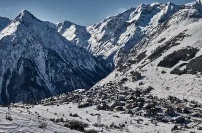
A gondola from town accesses a decent network of tree-lined slopes, nestled in the far southeast corner of the French Pyrenees.
Ski Club Recognised: Environmentally Sustainable Resort
The Ski Club uses third party independent assessments and accreditation of ski resorts to determine a resort “environmentally sustainable” – more information can be found here.
As part of the French Flocon Vert (tr. Green Snowflake) scheme, Font Romeu has been awarded one snowflakes out of a possible three, representing investment in resources to reduce its environmental impact. Flocon Vert is an independent scheme operated by Mountain Riders, which accredits resorts in France who have met twenty criteria based on environmental, social and economic sustainability.
- Font Romeu was accredited in 2022
- Particular attention has been paid to the resort’s comprehensive environmental strategy, which includes a green-focused development plan
- The resort was noted for its water strategy, including waste water management, reduced domestic consumption, and optimisation of artificial snow consumption
Resort (1947m)
| Mon 22 Sep | Tue 23 Sep | Wed 24 Sep | Thu 25 Sep | Fri 26 Sep | Sat 27 Sep | Sun 28 Sep | Mon 29 Sep | Tue 30 Sep | Wed 1 Oct | |||||||||||||||||||||
|---|---|---|---|---|---|---|---|---|---|---|---|---|---|---|---|---|---|---|---|---|---|---|---|---|---|---|---|---|---|---|
| AM | PM | Night | AM | PM | Night | AM | PM | Night | AM | PM | Night | AM | PM | Night | AM | PM | Night | AM | PM | Night | AM | PM | Night | AM | PM | Night | AM | PM | Night | |
| Weather | Broken clouds |
 Light rain |
  Rain/Snow shower |
 Light snow | Broken clouds |
Light drizzle |
Mist |  Generally clear |
Rather cloudy |
Light drizzle | Partly cloudy |
Partly cloudy |
Mainly fair | Partly cloudy |
Light rain shwr |
Generally clear | Some drizzle |
Occasional rain |
Light rain | Generally clear |
Light rain shwr |
Generally clear | Mainly fair |
Light rain shwr |
Generally clear | Mainly fair |
Light rain shwr |
Mainly fair |
| Wind |  |
 |
 |  |
 |
 | |
|
 | |
 |
| |
|
 | |
|
| |
|
 | |
 |
|  |
|
| |
|
|
| Snow expected | 0 cm | 0 cm | 0 cm | 0 cm | 0 cm | 0.8 cm | 0 cm | 0 cm | 0 cm | 0 cm | 0 cm | 0 cm | 0 cm | 0 cm | 0 cm | 0 cm | 0 cm | 0 cm | 0 cm | 0 cm | 0 cm | 0 cm | 0 cm | 0 cm | 0 cm | 0 cm | 0 cm | 0 cm | 0 cm | 0 cm |
| Max temp | 8.5°c | 10°c | 4°c | 4.6°c | 4.6°c | 1.5°c | 5.5°c | 6.1°c | 3.1°c | 8.7°c | 8.7°c | 5°c | 9.8°c | 9.9°c | 6.2°c | 11.1°c | 11.1°c | 7.3°c | 10.8°c | 10.8°c | 7.2°c | 11.2°c | 11.2°c | 8°c | 12.9°c | 12.9°c | 7.9°c | 13.3°c | 13.3°c | 8.9°c |
| Min temp | 3°c | 4°c | 2.9°c | 1.7°c | 1.5°c | -0.1°c | -0.7°c | 3.1°c | 0.3°c | -0.1°c | 5°c | 2.7°c | 2°c | 6.2°c | 3.9°c | 4°c | 7.3°c | 5°c | 4.6°c | 7.2°c | 5.8°c | 5.2°c | 8°c | 5.8°c | 5.4°c | 7.9°c | 6.3°c | 5.9°c | 8.9°c | 7°c |
| Feels like temp | 3.1°c | 6.8°c | 3.8°c | 1.6°c | 1.8°c | -1.1°c | -0.7°c | 3.3°c | 2.9°c | -0.1°c | 7.3°c | 4.8°c | 1.9°c | 8.7°c | 6°c | 3.7°c | 10.5°c | 7°c | 4.3°c | 9.9°c | 7.1°c | 5°c | 10.5°c | 7.9°c | 5.2°c | 12.7°c | 7.9°c | 5.6°c | 13.2°c | 8.9°c |
| AM | PM | Night | |
| Weather | |
|
|
| Wind | |
|
|
| Snow expected | 0 cm | 0 cm | 0 cm |
| Max temp | 8.5°c | 10°c | 4°c |
| Min temp | 3°c | 4°c | 2.9°c |
| Feels like temp | 3.1°c | 6.8°c | 3.8°c |
| AM | PM | Night | |
| Weather | |
|
|
| Wind | |
|
|
| Snow expected | 0 cm | 0 cm | 0.8 cm |
| Max temp | 4.6°c | 4.6°c | 1.5°c |
| Min temp | 1.7°c | 1.5°c | -0.1°c |
| Feels like temp | 1.6°c | 1.8°c | -1.1°c |
| AM | PM | Night | |
| Weather | |
|
|
| Wind | |
|
|
| Snow expected | 0 cm | 0 cm | 0 cm |
| Max temp | 5.5°c | 6.1°c | 3.1°c |
| Min temp | -0.7°c | 3.1°c | 0.3°c |
| Feels like temp | -0.7°c | 3.3°c | 2.9°c |
| AM | PM | Night | |
| Weather | |
|
|
| Wind | |
|
|
| Snow expected | 0 cm | 0 cm | 0 cm |
| Max temp | 8.7°c | 8.7°c | 5°c |
| Min temp | -0.1°c | 5°c | 2.7°c |
| Feels like temp | -0.1°c | 7.3°c | 4.8°c |
| AM | PM | Night | |
| Weather | |
|
|
| Wind | |
|
|
| Snow expected | 0 cm | 0 cm | 0 cm |
| Max temp | 9.8°c | 9.9°c | 6.2°c |
| Min temp | 2°c | 6.2°c | 3.9°c |
| Feels like temp | 1.9°c | 8.7°c | 6°c |
| AM | PM | Night | |
| Weather | |
|
|
| Wind | |
|
|
| Snow expected | 0 cm | 0 cm | 0 cm |
| Max temp | 11.1°c | 11.1°c | 7.3°c |
| Min temp | 4°c | 7.3°c | 5°c |
| Feels like temp | 3.7°c | 10.5°c | 7°c |
| AM | PM | Night | |
| Weather | |
|
|
| Wind | |
|
|
| Snow expected | 0 cm | 0 cm | 0 cm |
| Max temp | 10.8°c | 10.8°c | 7.2°c |
| Min temp | 4.6°c | 7.2°c | 5.8°c |
| Feels like temp | 4.3°c | 9.9°c | 7.1°c |
| AM | PM | Night | |
| Weather | |
|
|
| Wind | |
|
|
| Snow expected | 0 cm | 0 cm | 0 cm |
| Max temp | 11.2°c | 11.2°c | 8°c |
| Min temp | 5.2°c | 8°c | 5.8°c |
| Feels like temp | 5°c | 10.5°c | 7.9°c |
| AM | PM | Night | |
| Weather | |
|
|
| Wind | |
|
|
| Snow expected | 0 cm | 0 cm | 0 cm |
| Max temp | 12.9°c | 12.9°c | 7.9°c |
| Min temp | 5.4°c | 7.9°c | 6.3°c |
| Feels like temp | 5.2°c | 12.7°c | 7.9°c |
Resort Conditions
| Snowfall | Next 3 days | 1.7 cm |
|---|---|---|
| Depths | Upper piste depth | No information |
| Lower piste depth | No information | |
| Snow conditions | Snow quality | No information |
| Lifts | Lifts open | No information |
| Resort opening date | Sat 06 Dec 2025 | |
| Resort closing date | Sun 29 Mar 2026 |
France
Updated 02/05
Warm temperatures start the weekend, with the freezing line hitting 4,000m during the midday sun on Friday. This will fall, however, over the course of the long weekend, eventually hitting 2,000m on Monday evening and staying low throughout the new week.
Cloud will dominate this weekend, and with it will come precipitation. This will begin as rain on Saturday, but as things turn cooler this will turn to snow, with around 5cm falling across the region over Sunday evening, Monday and throughout Tuesday; this will fall on higher ground only as the freezing line remains on or just above 2,000m. High pressure returns in the middle of the week with plenty of fine, dry and bright conditions
Thus concludes this season’s snow overviews; thank you to everyone who has read them this season, and we look forward to seeing you again next year!


 France
