

 Share
Share Forecast today: Snow
- Max temp: -0.1 °c
- Min temp: -4.4 °c
- Last snowed: Wed 01 Apr
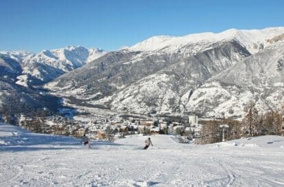
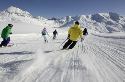
A gondola from town accesses a decent network of tree-lined slopes, nestled in the far southeast corner of the French Pyrenees.
Ski Club Recognised: Environmentally Sustainable Resort
The Ski Club uses third party independent assessments and accreditation of ski resorts to determine a resort “environmentally sustainable” – more information can be found here.
As part of the French Flocon Vert (tr. Green Snowflake) scheme, Font Romeu has been awarded one snowflakes out of a possible three, representing investment in resources to reduce its environmental impact. Flocon Vert is an independent scheme operated by Mountain Riders, which accredits resorts in France who have met twenty criteria based on environmental, social and economic sustainability.
- Font Romeu was accredited in 2022
- Particular attention has been paid to the resort’s comprehensive environmental strategy, which includes a green-focused development plan
- The resort was noted for its water strategy, including waste water management, reduced domestic consumption, and optimisation of artificial snow consumption
Resort (1947m)
| Wed 1 Apr | Thu 2 Apr | Fri 3 Apr | Sat 4 Apr | Sun 5 Apr | Mon 6 Apr | Tue 7 Apr | Wed 8 Apr | Thu 9 Apr | Fri 10 Apr | |||||||||||||||||||||
|---|---|---|---|---|---|---|---|---|---|---|---|---|---|---|---|---|---|---|---|---|---|---|---|---|---|---|---|---|---|---|
| AM | PM | Night | AM | PM | Night | AM | PM | Night | AM | PM | Night | AM | PM | Night | AM | PM | Night | AM | PM | Night | AM | PM | Night | AM | PM | Night | AM | PM | Night | |
| Weather | Snow |
Snow |
 Heavy snow | Snow |
 Light snow |
 Snow grains |
 Rather cloudy |
 Overcast |  Partly cloudy |
Mainly fair |
 Clear skies | Mainly fair |
Generally clear |
Generally clear | Generally clear |
Mainly fair |
Generally clear |  Occasional rain |
 Rain | Light snow |
Light snow |
Occasional snow | Occasional snow |
Light snow |
Snow | Light snow |
Light snow shwr |
Occasional snow |
| Wind |  |
 |
|  |
 |
|  |
 |
 |  |
|
 |  |
|
| |
 |
 | |
 |
 | |
 |
| |
|
|  |
|
|
| Snow expected | 5.5 cm | 13.9 cm | 21.1 cm | 6.6 cm | 3.7 cm | 3.9 cm | 0.1 cm | 0 cm | 0 cm | 0 cm | 0 cm | 0 cm | 0 cm | 0 cm | 0 cm | 0 cm | 0 cm | 0 cm | 0 cm | 0 cm | 0.1 cm | 1.1 cm | 0.2 cm | 0.9 cm | 0.2 cm | 0.1 cm | 3.4 cm | 0.4 cm | 0 cm | 1 cm |
| Max temp | -2°c | -0.2°c | -0.1°c | -1.5°c | -1.2°c | -0.4°c | 2.3°c | 2.9°c | 1.5°c | 8.8°c | 9.3°c | 6.2°c | 11.5°c | 11.6°c | 7.6°c | 13.3°c | 13.3°c | 8.7°c | 11°c | 11.1°c | 6.2°c | 1.9°c | 2.4°c | 1°c | 4°c | 4.2°c | 1.8°c | 3.4°c | 3.9°c | 1.7°c |
| Min temp | -4.4°c | -2°c | -0.8°c | -2.1°c | -1.7°c | -1.4°c | -0.7°c | 1.1°c | 0.7°c | 1.9°c | 6.2°c | 3.4°c | 3.6°c | 7.6°c | 4.1°c | 4.1°c | 8.7°c | 4.3°c | 4.1°c | 6.2°c | 1.7°c | 0.1°c | 1°c | -0.3°c | 0.3°c | 1.8°c | 0.6°c | 0.5°c | 1.7°c | 0.3°c |
| Feels like temp | -9.7°c | -7.9°c | -6.3°c | -5.5°c | -6°c | -5.5°c | -0.7°c | -0.7°c | 1°c | 1.8°c | 8.2°c | 5.7°c | 3.2°c | 10.6°c | 7.2°c | 1.9°c | 12°c | 7.2°c | 1.2°c | 9.3°c | 5.8°c | 0.1°c | -0.8°c | 0.9°c | 0.3°c | 1.4°c | -1.2°c | -2.4°c | 0.4°c | -0.7°c |
| AM | PM | Night | |
| Weather | |
|
|
| Wind | |
|
|
| Snow expected | 5.5 cm | 13.9 cm | 21.1 cm |
| Max temp | -2°c | -0.2°c | -0.1°c |
| Min temp | -4.4°c | -2°c | -0.8°c |
| Feels like temp | -9.7°c | -7.9°c | -6.3°c |
| AM | PM | Night | |
| Weather | |
|
|
| Wind | |
|
|
| Snow expected | 6.6 cm | 3.7 cm | 3.9 cm |
| Max temp | -1.5°c | -1.2°c | -0.4°c |
| Min temp | -2.1°c | -1.7°c | -1.4°c |
| Feels like temp | -5.5°c | -6°c | -5.5°c |
| AM | PM | Night | |
| Weather | |
|
|
| Wind | |
|
|
| Snow expected | 0.1 cm | 0 cm | 0 cm |
| Max temp | 2.3°c | 2.9°c | 1.5°c |
| Min temp | -0.7°c | 1.1°c | 0.7°c |
| Feels like temp | -0.7°c | -0.7°c | 1°c |
| AM | PM | Night | |
| Weather | |
|
|
| Wind | |
|
|
| Snow expected | 0 cm | 0 cm | 0 cm |
| Max temp | 8.8°c | 9.3°c | 6.2°c |
| Min temp | 1.9°c | 6.2°c | 3.4°c |
| Feels like temp | 1.8°c | 8.2°c | 5.7°c |
| AM | PM | Night | |
| Weather | |
|
|
| Wind | |
|
|
| Snow expected | 0 cm | 0 cm | 0 cm |
| Max temp | 11.5°c | 11.6°c | 7.6°c |
| Min temp | 3.6°c | 7.6°c | 4.1°c |
| Feels like temp | 3.2°c | 10.6°c | 7.2°c |
| AM | PM | Night | |
| Weather | |
|
|
| Wind | |
|
|
| Snow expected | 0 cm | 0 cm | 0 cm |
| Max temp | 13.3°c | 13.3°c | 8.7°c |
| Min temp | 4.1°c | 8.7°c | 4.3°c |
| Feels like temp | 1.9°c | 12°c | 7.2°c |
| AM | PM | Night | |
| Weather | |
|
|
| Wind | |
|
|
| Snow expected | 0 cm | 0 cm | 0.1 cm |
| Max temp | 11°c | 11.1°c | 6.2°c |
| Min temp | 4.1°c | 6.2°c | 1.7°c |
| Feels like temp | 1.2°c | 9.3°c | 5.8°c |
| AM | PM | Night | |
| Weather | |
|
|
| Wind | |
|
|
| Snow expected | 1.1 cm | 0.2 cm | 0.9 cm |
| Max temp | 1.9°c | 2.4°c | 1°c |
| Min temp | 0.1°c | 1°c | -0.3°c |
| Feels like temp | 0.1°c | -0.8°c | 0.9°c |
| AM | PM | Night | |
| Weather | |
|
|
| Wind | |
|
|
| Snow expected | 0.2 cm | 0.1 cm | 3.4 cm |
| Max temp | 4°c | 4.2°c | 1.8°c |
| Min temp | 0.3°c | 1.8°c | 0.6°c |
| Feels like temp | 0.3°c | 1.4°c | -1.2°c |
Resort Conditions
| Snowfall | Last Snowfall | 01/04/2026 |
|---|---|---|
| Next 3 days | 53.2 cm | |
| Depths | Upper piste depth | 80 cm |
| Lower piste depth | 70 cm | |
| Snow conditions | Snow quality | Hard packed |
| Lifts | Lifts open | 12 out of 23 |
| Resort opening date | Fri 05 Dec 2025 | |
| Resort closing date | Mon 06 Apr 2026 |
France
Updated 24/03
What must be the first Nordstau event of the year hits the Alps over the course of this week, bringing a return to winter conditions across much of the Northern French Alps. The freezing line will decline through the middle of this week, dropping close to sea level overnight Thursday into Friday.
At the same time, northerly unsettled conditions working their way in across Central and Eastern Europe brings snowfall to many areas north of the Briancon-Gap line. Over higher ground this could see as much as a foot-and-a-half through Wednesday evening and into Thursday; as the freezing line declines over this period, snow will work its way down to lower elevations, but the best conditions will remain above 2,000m.
A brief pause in the snowfall over Saturday still sees cloudy conditions dominating; a few more flurries move in over higher ground on Sunday, as the freezing line recovers to around 2,000m. The long term forecast then calls for sun and fine, dry and bright conditions to dominate as high pressure returns to the area.
Showing 21 discounts


New Generation Ski & Snowboard School
10% discount across New Generation bookings for all Ski Club Members


 Italy
Italy 
 France
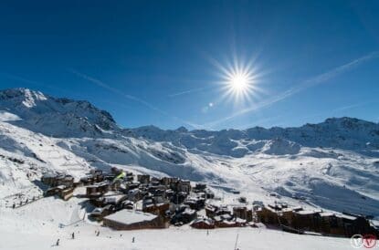